
Tunica Hills WMA Trail B
My favorite place to hike around Baton Rouge is the Tunica Hills Wildlife Management Area. The area is located just north of St Francisville and provides the best challenge for hikers with three short loop trails. This trail is unique to the area because it includes a short nature trail and is not a true loop trail but a lollipop (think a straight line with a small loop at the end). At 3.5 miles it is a great day hike when you want to get away from the "big city" of Baton Rouge.

The trailhead is located directly across from the trail head for trail C
The trailhead has maps for the entire trail system for the WMA. I recommend grabbing one as the trail can be poorly marked in some areas. I've also included a printable map on this page. The nature trail is blazed with green markers and trail B is blazed with blue markers. The trail starts as an old roadbed and heads slightly uphill. Once at the top of this hill you will come to the exit for the nature trail. Continue a little bit further and you'll see the start for the nature trail.
Quick Stats
Length: 3.5 Miles
Difficulty: Hard
Loop

Start nature trail here, to the left

Several trees and plants are identified with small signs

This nature trail is short and well marked. Head back to the main trail B
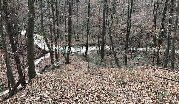
Once you complete the short nature trail, and return to the main trail B, turn left and pass the start of the nature trail. I did this hike in the winter time so the leaf-off allowed for views of the surrounding hills. The trail is relatively flat for a while and the hilltop begins to narrow leaving some impressive drop offs down into the ravines on either side. Soon Bayou Como comes into view on the right and the trail will steeply drop down to it.
Heading down to Bayou Como
Every time I have hiked this area Bayou Como has just been a dry sandy walk. Expect more wet conditions after heavy rainfall. The trail doesn't stay in the bayou long and a marker on the right indicates that the trail is heading back uphill. The trail stays up high for the next mile or so and intersects an ATV trail for part of the way.

Heading back up from Bayou Como

Markers along the way have letters and numbers that correspond with the trail map

Lightning strike??
Heading back down to the bayou, the trail makes a left to head back and complete the loop of this "lollipop trail". Be careful not to stray into the woods to the right of the bayou, this is private property for a local hunting club. Pass marker B5 where the loop began. Head back uphill and back to the trailhead.